
How much time we wasted to figure out where a land or building parcel is located on the territory!
![]()
CatOnE is the Web application provided for local governments in order to make easy and fast the consultation of the cadastral database with the visualization of maps overlapped on satellite imagery available on commercial Web platforms.
![]()
CatOnE is a cartographic tool which allows the identification of the parcels from the street address and vice versa.
![]()

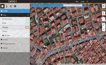
The main functions of the application are the following:
• Search for cadastral or tax code for both land and building identification with automatic positioning on the cartography;
• Search of the parcel typing the street and/or house number code with the access to the Registry;
• Consultation of the digital cartography with the access to additional cartographic layers, such as the urban planning, the environment data, risk maps, … .
![]()