

Map CatOnE Healt
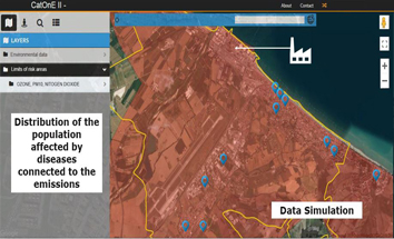
The view of the health data related to the territory introduces a new vision of data analysis connected to the position of the residence of citizens.
![]()
The health data for each citizen is connected to the anagraphic data of the family and the position of the residence is related to the location of health and social services.
![]()
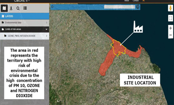
In this context the digital cartography is a tool for planning a detailed assistance for citizens, like the home assistance.
![]()
Main functions of the web application :
· georeferenced data for epidemiological research;
· registry resident data query (name, surname, fiscal code, street address, family status, helath data);
. Overlap of tematic maps;
· Boolean relationships between georeferenced areas and people living inside the selected areas;
· Display of the information sheets for the assisted citizens.
![]()